
This page shows case studies of EM surveys conducted with GPS positioning.
|
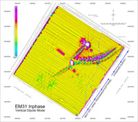
The study area is of a size approximately 265 x 280 m (17 acres). The EM31 survey was started from NE using standard data acquisition software. Then next day, the remaining southwestern portion of the site was surveyed using TrackMaker31. The attached map contains EM31 Inphase data. Please click on the image to enlarge. |
 |
||||
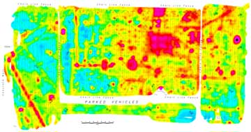
| This is 42 acres site (2,200 x 920 feet) surveyed with Geonics EM61-MK2 and TrackMaker. Survey lines are spaced approximately 5 feet apart over the entire site. Presented image shows EM61-MK2 Channel 3. A section ( northern portion of the site ) is presented separately to show survey layout in detail. Please click on images to enlarge. |
 |
 |
|||
| The EM31 survey covered almost entire island ( over 80 acres, approx. 1,100 m along WE ) that includes landfill areas. The site contains lots of trees and bushes, therefore some lines are far from perfect. All topographical features (shoreline, roads, monitoring wells, etc.) placed on this map can serve as an example how TrackMaker can be used as a standalone GPS logger. Please click on images to enlarge. |
 |
||||
|
|
|||||
| An example of Geonics EM61-MK2 (Channel 3) survey with DGPS positioning is shown below. It is a site of a size approximately 600 x 300 feet. | |||||
 |
 |
||||
| Please click on images to enlarge, a section of the survey area shows lines separation and stations distribution in more detail.. | |||||